Intro to FORTE
BACKGROUND
Today’s Arctic is a rapidly evolving environment with both local and global implications. Previous scientific work has substantially increased our understanding of environmental processes on Arctic marine and terrestrial ecosystems. This progress has also highlighted that the need for research connecting processes between the Arctic land and Arctic Ocean has never been greater.
Hydrological and biogeochemical exchanges between these two interconnected systems—the land and the ocean—shape a new Arctic that is undergoing a fundamental regime shift. Yet, the Arctic land-river-ocean aquatic continuum, one of the most critical areas on Earth for energy resources, transportation, security, subsistence, biodiversity and cultural heritage, is yet to be thoroughly characterized and assessed in the face of global change.
Airborne remote sensing observations provide an unparalleled capability to capture the hydro- biogeochemical connectivity of land-ocean ecosystems, at scales not feasible with field-based monitoring alone. Nowhere is this more profoundly true than in the remote and difficult to access coastal Arctic.
NASA'S ROLE
NASA is focused on developing new ways to observe and study Earth's interconnected systems, over the short and long term, to increase our understanding of our home planet, improve lives, and safeguard our future. Toward this goal, NASA uses observations from a fleet of satellites and ambitious airborne and ground-based campaigns to study complex processes on Earth, drive innovations, and deliver science to help inform decisions that benefit the nation and the world.
Arctic Coastlines: Frontlines Of Rapidly Transforming Ecosystems (FORTE) is a NASA Earth Venture Suborbital Mission to apply the unique advantages of high resolution, ecosystem-scale, suborbital passive and active remote sensing observations to explicitly link complex hydrological, biogeochemical and ecological processes in Arctic land-ocean systems. FORTE will fill a critical gap in our mechanistic understanding and modeling of environmental variations and their impacts, by targeting the transitional continuum of Alaska's northernmost ecosystems - eroding coastlines, rivers, deltas, and estuaries - that connect land to sea: a dynamic continuum that can uniquely be captured from airborne platforms. The science of FORTE is guided by three thematic research areas:
- The impact of intensified Arctic River discharge on river plumes, coastal erosion, water quality, and spatiotemporal transitions between sources and sinks of carbon and energy.
- Changes in the relative importance and interplay of coupled physical/biogeochemical processes in transforming land-ocean fluxes, as environmental conditions change in the Arctic.
- The response of phytoplankton populations to changing environmental conditions, also as it relates to growing risk of harmful algal blooms and impacts on local marine resources and food security.
These accelerating changes - in coastal resources, water quality, subsistence activities, coastal erosion and infrastructure - are of key concern to local communities, industrial development, and economic prosperity in the region.
To address these science objectives FORTE will conduct an intensive 4-year field-campaign program (FY26-FY29) with field work in 2027 and 2028. Measurements will focus on the North Slope of Alaska, a region of increasing economic activity that is also characterized as a high priority area for coordinated monitoring of future environmental change across the Pan-Arctic. Intensive measurements will be conducted across the four largest river systems that drain North Alaska - Colville, Kuparuk, Sagavanirktok and Canning - and have different geomorphological and ecosystem characteristics.
FORTE OBSERVING APPROACH
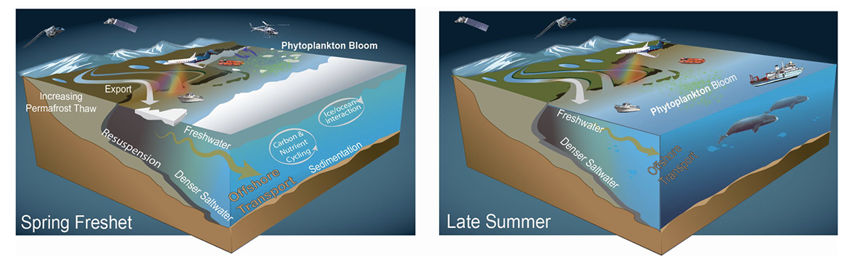
Airborne and other suborbital platforms in FORTE will be strategically integrated over four different deployments (FY27-FY28) capturing very different states of the river-to-sea ecosystem for multiple seasons (from spring freshet to late summer).
High priority airborne observations from crewed and uncrewed aircraft (UAVs) will include measurements of hyper-spectral (UV-Vis-NIR) water remote sensing reflectance for retrievals of in-water constituents and aquatic (inland and coastal water) physical, biogeochemical and physical processes. Additional measurements of interest from airborne platforms include land surface reflectance, sea surface and land surface temperature, coastal salinity, coastal erosion, soil moisture and permafrost surface freeze/thaw state.
Surface measurements will include (i) ship/boat-based sampling of the lower reaches of rivers and nearshore sea; (ii) helicopter and/or surface vehicle based sampling when ship/boat operations are not possible during spring-freshet due to hazardous conditions; (iii) surface- water/groundwater sampling and process-based experiments from spring to fall; (iv) local community-based sampling and measurements from autonomous monitoring buoy systems/moorings will extend the coverage and resolution of observations, continuously monitoring discharge, physicochemical parameters, and optical proxies of biological activity, to the extent allowable by river and sea ice.
Satellite observations, primarily from relatively high spatial resolution (10-300 m) sensors, will augment suborbital measurements with retrievals of ocean color, inland and coastal water biogeochemistry and biology, landfast ice, coastal erosion, permafrost dynamics, and surface temperature.
Model development in FORTE will focus on coupling the terrestrial-hydrologic system with the river-delta-ocean system with mechanistic aquatic physics and biogeochemistry. River ice dynamics, landfast ice, and physics will be simulated, driving a biogeochemical modeling system that includes organic and inorganic carbon, nutrients, phytoplankton, sediment, optical properties, and coastal erosion. Simulations will include observation years and extrapolate back greater than 10 years to estimate interannual variability.
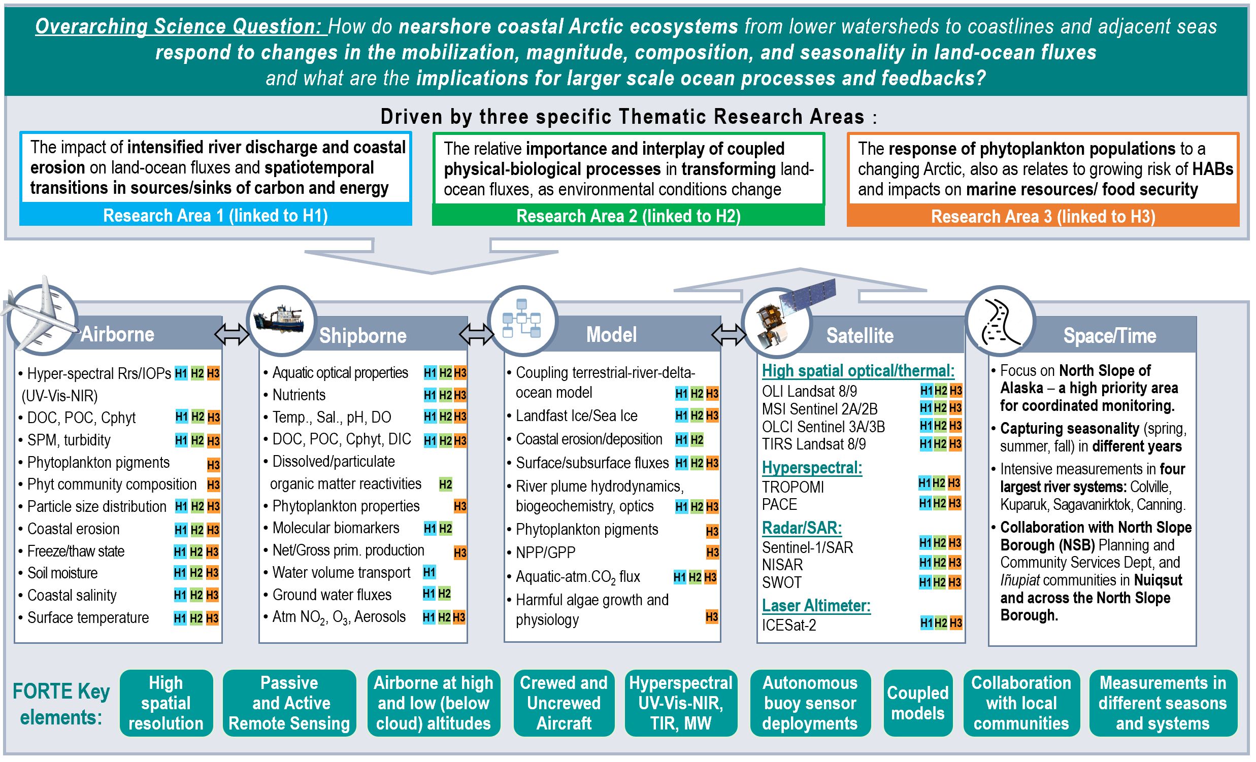
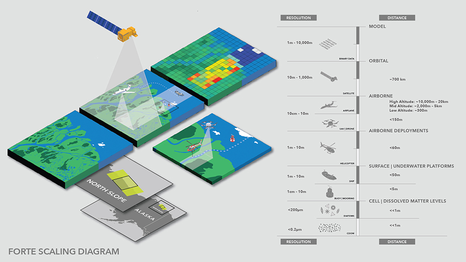
FORTE SCALING DIAGRAM
FORTE will integrate observations from surface, airborne, and satellite platforms to improve our mechanistic understanding and modeling of environmental change impacts on the coastal Arctic – from the micro to the ecosystem scale.