FireSense conducts regular airborne campaigns over wildland fires and prescribed burn units to evaluate and test newly developed capabilities and to collect both remotely-sensed and in situ data that can inform management decisions and improve fire models. FireSense is focused on four uses-cases to improve wildfire management. These include the measurement of pre-fire fuels conditions, active fire dynamics, post-fire impacts and threats, as well as air quality forecasting, each co-developed with identified wildfire management agency stakeholders.
Data submission from the FireSense campaigns will be sent to a FireSense data repository developed by FireSense Implementation
Team members at NASA Langley for QA/QC. Data access for analysis and publication can be found at the following Earthdata repositories: DAACs,
AVIRIS-3 L1B and AVIRIS-3 L2A.
The platform supports storage for documents, text delimited files (csv), geospatial data (point/polygon, geotiff, netcdf, laz,), as well as providing password protection on a government system. This is the same data
system that supports other NASA airborne campaigns, including the FIREX-AQ project.
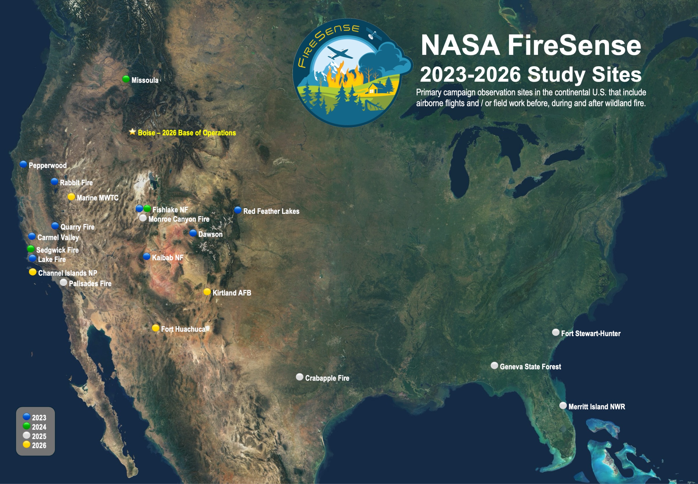
In 2026 FireSense campaign activities are planned in the Western United States. Primary objectives include demonstration and evaluation of new wildland fire technologies and collection of measurements to characterize fuels conditions. FireSense has planned its summer 2026 flights to overlap with the INSPYRE EVS-4 mission to leverage those instruments for validation and to extend potential datasets.
The science instruments planned are:
The technology demonstration instruments planned are:
The FireSense Summer 2026 Campaign will take place between July 25, 2026 and August 14, 2026, with the following targets:
- Fire-prone landscapes representing diverse fuel types (e.g., western shrublands, mixed conifer forests). Planned locations include: Fort Huachuca, AZ; Kirtland AFB, NM; Marine Mountain
Warfare Training Center, CA; and Whittell Forest and Wildlife Area, NV.
- Type 1, 2 and 3 fires in the Western U.S. that exhibit potential for high growth due to winds, terrain, and/or convection.
- Department of War, Strategic Environmental Research and Development Program (SERDP) and the Environmental Security Technology Certification Program (ESTCP)
- National Oceanic and Atmospheric Administration (NOAA) National Weather Service (NWS)
- National Interagency Fire Center Incident Awareness and Assessment (IAA)
- NASA's INjected Smoke and PYRocumulonimbus Experiment (INSPYRE) EVS-4 mission
In 2025 FireSense campaign activities occurred in the southeastern United States, specifically Geneva State Forest in Alabama, Merritt Island National Wildlife Refuge in Florida, and Fort Stewart in Georgia, as well as surrounding states including TX, MS and OK. Primary objectives include demonstration and evaluation of technology to support wildland fire management decisions and collection of measurements to validate prediction models for wildland fire and smoke management.
The aircraft, UAVs, and instruments used were:
Data from the FireSense campaigns will be stored in a
FireSense data repository.
Airborne Visible/Infrared Imaging Spectrometer 3 (AVIRIS-3)
- Visible and Short-Wave Infrared (VIS-SWIR)
- Vegetation Composition, Fire Behavior, Fire Effects
MODIS/ASTER Airborne Simulator (MASTER)
- Visible, Mid-Wave Infrared, Thermal Infrared (VIS-MWIR-TIR)
- Fire Radiative Power
UAV Based Data Collection
- LiDAR, Meteorological, Infrared Sensors
- 3D Elevation, temperature, atmospheric pressure, relative humidity, wind speed and direction
- Vegetation structure, fire behavior, atmospheric conditions, and wind profiles
Tactical Fire Remote Sensing (TACFI-RS)
- Time Based Fire location and intensity
- Fire behavior characteristics
Fire Thermal Infrared Imaging System (FireTIRS)
- Multispectral thermal infrared sensor
- Fire behavior characterization,
- Trace gasses, thermal fluxes
Fuel and Soil Sampling
- Temperature and moisture
- Fuel load
- Post-fire soil burn severity and ash
Rapidly Deployable Atmospheric Profiling System (RaDAPS)
- Wind profiler, lidar ceilometer, Rain Radar, Doppler sodar, parsivel disdrometer, microwave profiling radiometer
- Boundary layer, aerosol, and cloud characteristics. Temperature, relative humidity, precipitation, atmospheric pressure, and wind profiles.
Mobile Operated Doppler Lidar System (MoDLS)
- Doppler Wind LiDAR, radiosondes, surface measurements
- Surface meteorology; wind measurements and temperature
The FireSense Spring 2025 Campaign occurred in two phases with Phase I occurring between March 17-28 2025, and Phase II occurring April 12-20, 2025.
Phase I included data
collection over “targets of collaboration,” such as wildland fires in Florida, Alabama, Mississippi, Texas, and Oklahoma as well as a coordinated prescribed fire research activity
in southern Alabama.
Phase II included a series of flights over prescribed fires at Fort Stewart Hunter Army airfield, select targets of collaboration, and pre- and post-fire
flights over Merritt Island National Wildlife Refuge.
- Alabama Forestry Commission
- National Interagency Fire Center Incident Awareness and Assessment (IAA) Group
- Department of War, Strategic Environmental Research and Development Program (SERDP) and the Environmental Security Technology Certification Program (ESTCP)
- US Forest Service
During 2024, one aircraft and multiple
unmanned aerial vehicles (UAVs) were deployed
and equipped with passive and active remote
sensing instruments to sample vegetation
structure, fire behavior and effects,
atmospheric conditions, and areas affected by
wildland and prescribed fires in the Western
United States.
The aircraft, UAVs, and instruments used were:
Data from the FireSense campaigns will be
stored in a
FireSense data repository.
Expected data products and potential use are
listed. Some additional data products will be
added.
-
Visible and Short-Wave Infrared (VIS-SWIR)
-
Vegetation Composition, Fire Behavior,
Fire Effects
UAV Based Data Collection
-
LiDAR, Meteorological, Infrared Sensors
-
3D Elevation, temperature, atmospheric
pressure, relative humidity, wind speed
and direction
-
Vegetation structure, atmospheric
conditions, and wind profiles
Observation sites included in 2024 FireSense campaign activities that focused on air quality and atmospheric measurements, as well as post-fire airborne data collection.
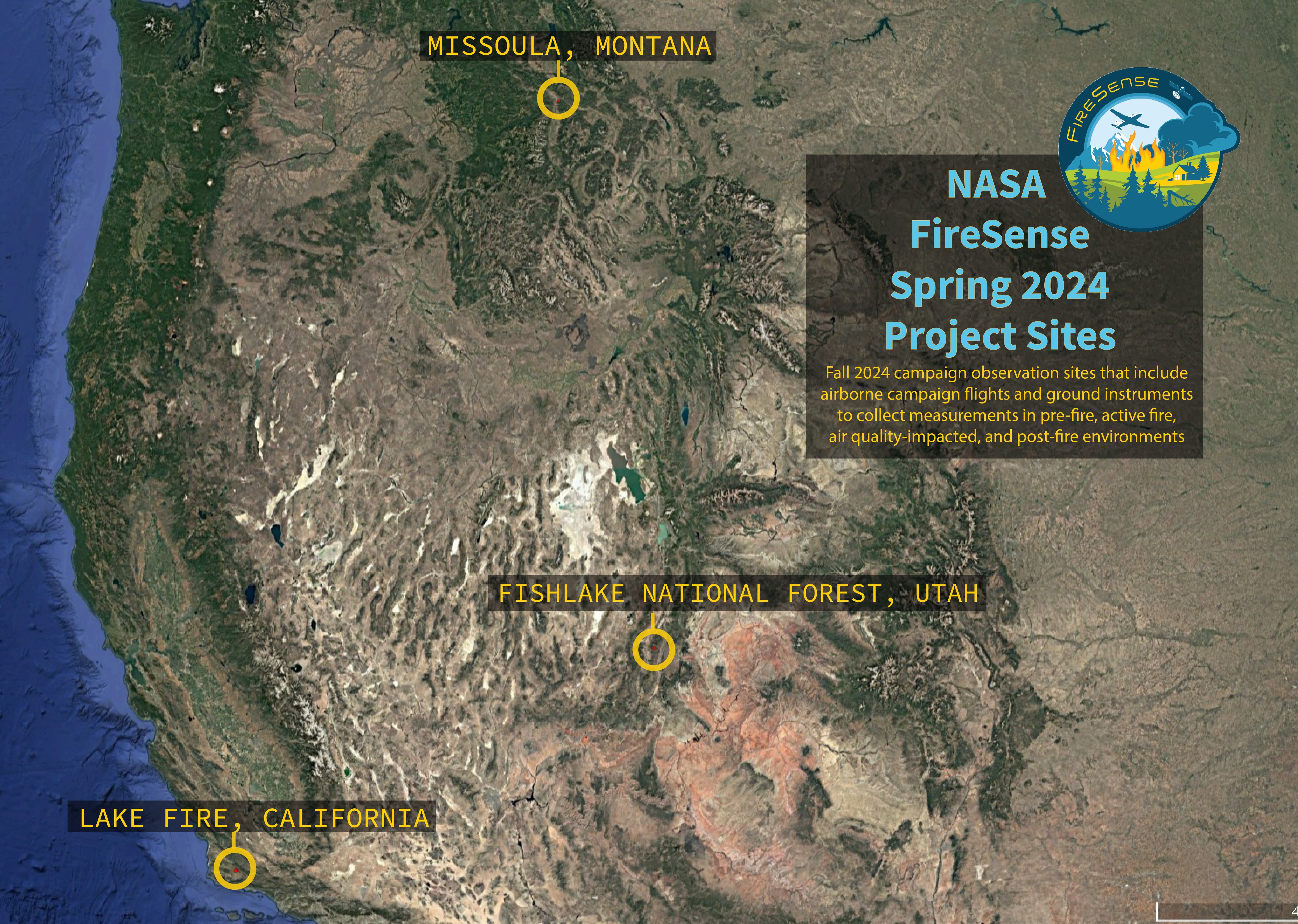
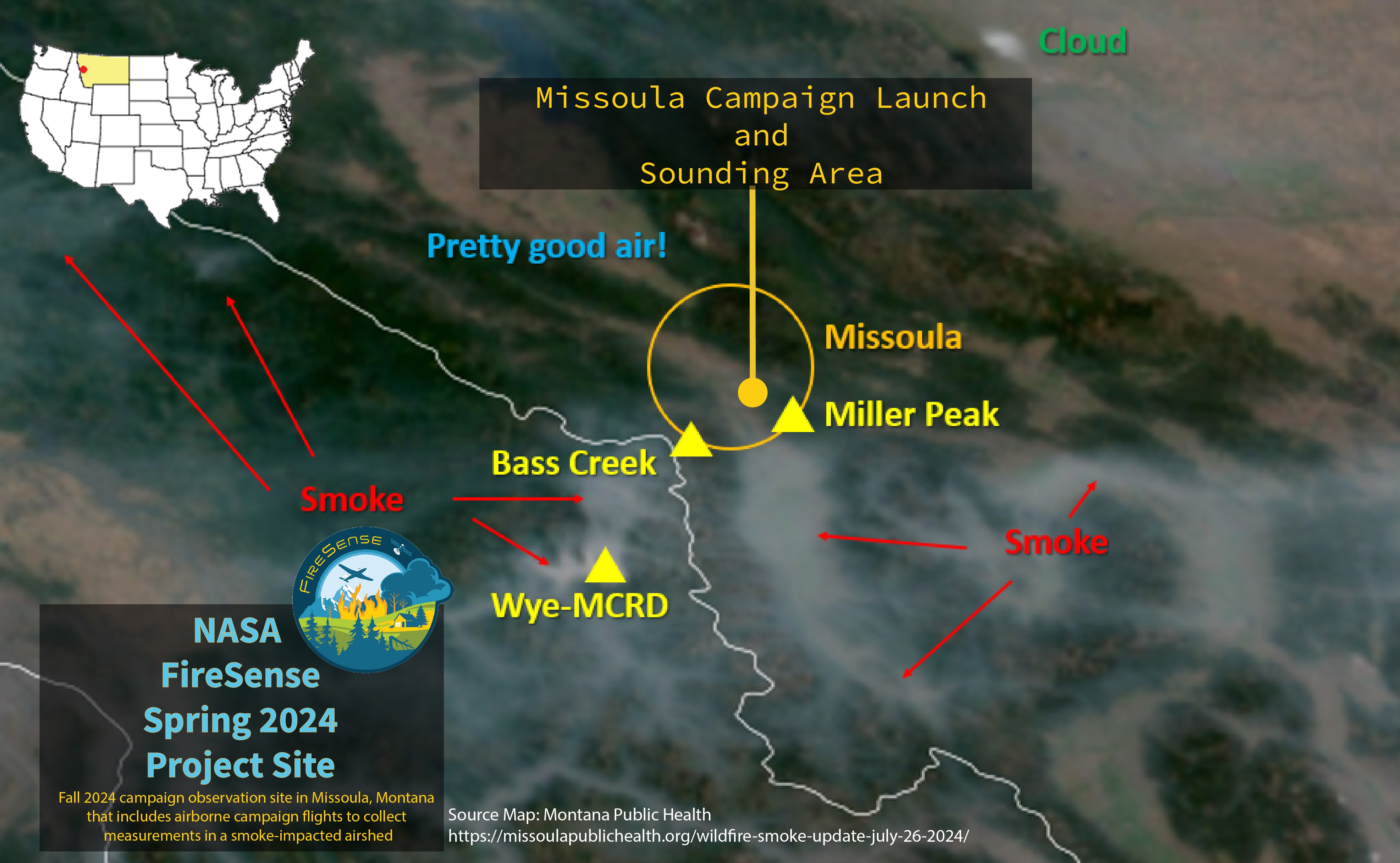
The Fall 2024 campaign observation site in Missoula, Montana, that included atmospheric soundings and data collection within a smoke-impacted airshed.
- MITRE
- ESRI
- University of Montana
- US Forest Service
- National Oceanic and Atmospheric Administration
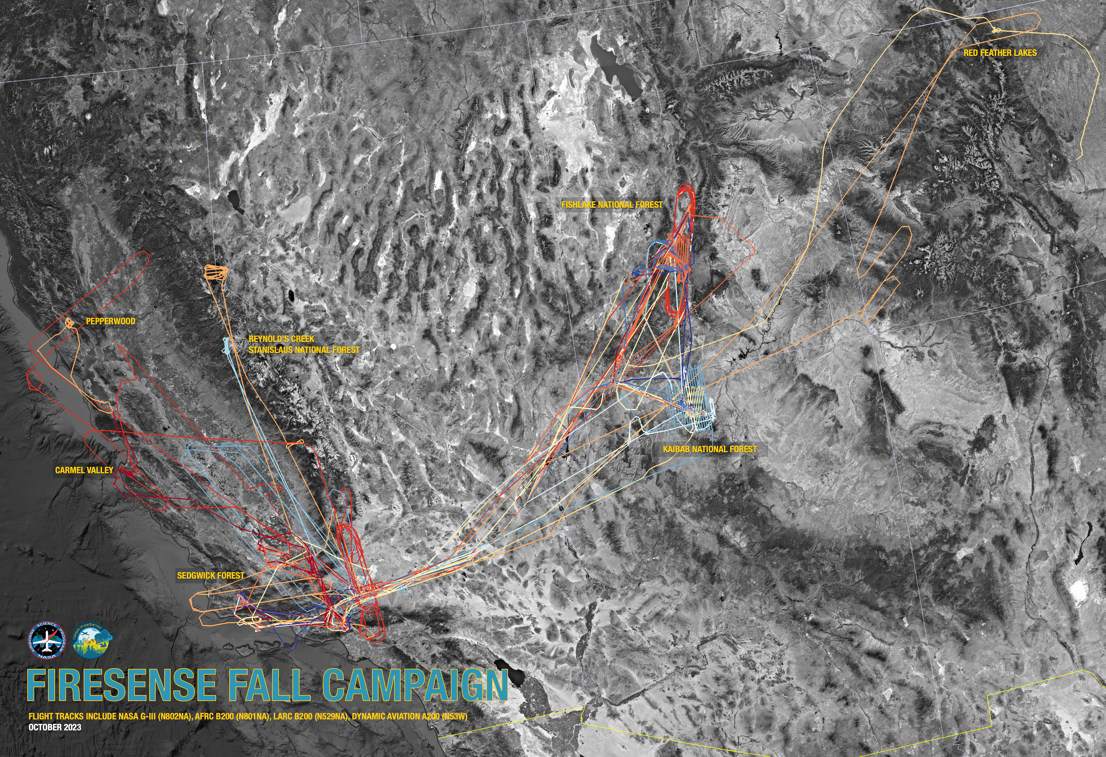
During the fall 2023 deployment, four aircraft
were deployed and equipped with active and
passive airborne remote sensing instruments to
sample vegetation, soil moisture and areas
affected by wildland and prescribed fires in
the western United States.
The aircraft and instruments included were:
Flight details for the 2023 campaign can be
found at the
ESPO FireSense website.
Data from the FireSense campaigns will be
stored in a
FireSense data repository.
Expected data products and potential use are
listed. Some additional data products will be
added.
-
Visible and Short-Wave Infrared (VIS-SWIR)
-
Vegetation Composition, Fire Behavior,
Fire Effects
-
Visible, Mid-Wave Infrared, Thermal
Infrared (VIS-MWIR-TIR)
- Fire Radiative Power
- L-Band Active Radar
-
Estimated moisture in vegetation, fuels
and soil
- L-Band Active & Passive Radar
-
Estimated moisture in fuels and soil
San Jose State University Wildfire Imaging
System (SWIS)
- Visible and Infrared Imagery
- Fire Dynamics, Radiative Power
B-200/C-20A Meteorological and Navigation
data
Field Reports
The 2023 campaign primary observation sites in
the Western U.S. include significant airborne
flights with complementary ground measurements
when possible.