KEY SCIENCE ISSUE Invasive species, non-native plants or animals that adversely impact the areas they inhabit, are considered a major contributor to environmental change. The location and degree of ecological impact of invasions, however, are difficult to quantify at regional or global scales.
FINDINGS Scientists from the Carnegie Institution in Stanford, Calif. used airborne remote sensing instruments, an imaging spectrometer and a lidar, to determine how biological invasion alters the chemistry and 3-dimensional
(3-D) structure of rainforests in Hawaii. They identified multiple pathways by which invasive species transform the structure and chemical properties of native rainforests. Some invasive tree species replace native mid-canopy and
understory plants and more than double the amount of nitrogen and water taken from the soil. Another understory invader excludes native species at the ground level, and it steals nitrogen from neighboring native trees. Another
invasive nitrogen-fixing tree, in combination with a mid-canopy alien tree, replaces native plants at all canopy levels in lowland forests, creating a biological impoverished, alien rainforest. The science team concluded that this
diverse array of alien plant species, each representing a different growth form or functional type, is changing the fundamental 3-D structure of Hawaiian rainforests.
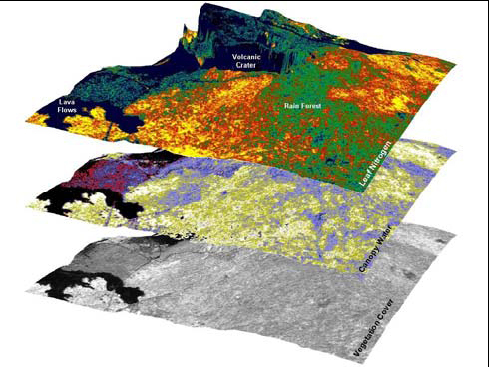
METHOD The scientists combined the NASA Airborne Visible and Infrared Imaging Spectrometer, known more commonly as AVIRIS, with the Carnegie Airborne Observatory Waveform Lidar on a Twin Otter airplane to map the chemical
and structural properties of the rainforests. The sensors were integrated onboard the aircraft, and new data processing algorithms were used to analyze the AVIRIS and lidar simultaneously. The laser-guided spectroscopic results
allowed identification of the invasive species and their ecological effects.
SIGNIFICANCE TO THE PUBLIC This novel remote sensing approach indicates the geographic extent, intensity, and biogeochemical impacts of highly invasive species that destroy native rainforest reserves in Hawaii. The
study demonstrates how a new airborne mapping strategy can identify and track the spread of certain invasive plants and provide detailed geographic information to conservation and management efforts.
NEXT STEPS The scientists plan to expand the study to cover more rainforest reserves in Hawaii, and to improve the methods by which invasive and native plant species are detected and mapped from the air. The team hopes
to enhance the generality of the methods so they can be
useful in other ecosystems outside of Hawaii.