KEY SCIENCE ISSUE Forest disturbance from fire, harvest, insect damage, storm damage, or other significant occurrences exerts a strong control on the cycling of terrestrial carbon, but disturbance rates have never been comprehensively mapped across North America.
FINDINGS Scientists conducting three recent studies have used NASA satellite data to map the extent, history, and recovery associated with forest disturbance. These studies have found that disturbances due to logging are pervasive throughout the southeastern United States, Quebec/Maine region, and Pacific Northwest. In these areas, 2-3 percent of forest cover may be affected by disturbance each year. An initial wall-to-wall estimate of North American forest disturbance suggests that ~0.9 percent +/-0.2 percent of "lower 48" U.S. forest land is disturbed each year by large "stand clearing" events. Investigations have also shown that in some instances, decadal changes in vegetation productivity in the mid-latitudes that might have been ascribed to climate change may instead reflect post-disturbance forest recovery from fire activity, insect outbreaks and/or clearing of forests by humans. These findings complement data from other sources such as U.S., Canadian and Mexican forest inventories, and provide a basis for detailed modeling of changes in forest species composition and forest carbon storage and fluxes to the atmosphere.
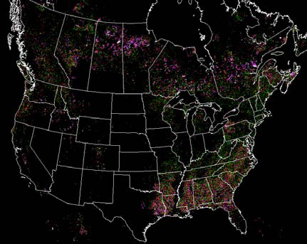
North American forest disturbance intensity, 1990-2000, mapped from about 2200 Landsat images. Colors represent the percent of each 500x500m cell disturbed during the mapping epoch. Credit: NASA/Jeff Masek
METHOD The suite of studies relied on multi-temporal NASA/USGS Landsat imagery to track changes in the forest cover of North America. A wall-to-wall decadal (1990-2000) change map was supplemented with dense image
time series (one image every 1-2 years) for a sample of 25 locations across the U.S. Finally, coarse-resolution NOAA Advanced Very High Resolution Radiometer data were used to identify regions showing pronounced interannual changes
in vegetation productivity. High-resolution Landsat data were acquired for these regions to determine whether the changes in vegetation productivity corresponded to disturbance associated with land-cover change or climate impacts
on ecosystem processes.
SIGNIFICANCE TO THE PUBLIC Frequent disturbances produce a forest mosaic of varying age, composition, and structure. This "patch work" ecosystem, in part man-made, affects plant and animal diversity and abundance.
In addition, forests currently sequester about 13 percent of U.S. fossil fuel emissions. Accurate predictions of future atmospheric CO2 levels will not be possible unless we understand how forests (and other land vegetation) exchange
carbon, including the response of vegetation systems to ecosystem disturbance. Our analyses of forest disturbance provide a basis for improved prediction of carbon sources and sinks from biogeochemical models.
NEXT STEPS Follow-on projects are extending the number of Landsat time series samples from 25 to 50, which will reduce uncertainties in continental disturbance estimates, and extend wall-to-wall mapping to 2005. Work
is also ongoing to estimate rates of biomass accumulation in recovering forests from spectral-temporal trajectories. This would allow us to directly estimate the amount of carbon being taken up by forests during early re-growth.
One critical goal is to combine or "fuse" the results from these satellite-based projects with those derived from related projects (e.g. burned area mapping by the US Forest Service and the Canadian Forest Service; forest
insect/disease outbreak maps, etc) in order to produce an integrated view of forest ecosystem dynamics during the last ~50 years.
For more information, contact:
Lynn Chandler, Goddard Space Flight Center, 301-286-2806, lynn.chandler-1@nasa.gov
