KEY SCIENCE ISSUE Tropical Montane Cloud Forests (TMCFs) are biologically diverse ecosystems that are characterized by frequent and prolonged immersion within orographic clouds, which can engulf entire ecosystems in a misty fog. Orographic clouds are clouds that originate as moist air rises and cools over mountains. The majority of flora and fauna within TMCFs rely on moisture input from these clouds, especially during dry seasons when harvesting of cloud water by vegetation can account for up to 15-100 percent of total precipitation. Studies show decreasing dry season moisture input from orographic clouds at Monteverde, Costa Rica since the 1970s, which has been attributed to a shift in cloud height due to climate change. These changes may be responsible for population crashes of species observed in this area during the same time period. The distribution of biodiversity in TMCFs is poorly understood and requires an understanding of the extent of cloud immersion, which is hard to observe in remote locations. Mapping the distribution of biodiversity in these ecosystems is essential for understanding ecosystem processes and for conservation.
FINDINGS Udaysankar Nair, of the University of Alabama in Huntsville, says numerical modeling studies utilizing NASA satellite data have found that lowland deforestation in Costa Rica at locations upwind of Monteverde
caused the air to become warmer and drier, leading to increased cloud base height. Thus land use change in the lowland areas has the potential to impact TMCFs at remote locations downwind. NASA satellite data have been used to
quantify cloud immersion at Monteverde and at other locations in Central America. Comparison of areas of frequent cloud immersion as determined from data captured by NASA's Moderate Resolution Imaging Spectroradiometer (MODIS)
with known cloud forest locations show that satellite data can be effectively used to map the geographical distribution of cloud forests.
METHOD Nair and his colleagues used the Regional Atmospheric Modeling System to study the impact of lowland deforestation on cloud forests in Monteverde, Costa Rica. MODIS data were used to derive land use and vegetation characteristics, which were then used to specify land use scenarios in computer simulations. The MODIS cloud and atmospheric data along with the United States Geological Survey Digital Elevation Model and National Center for Environmental Prediction global analysis data sets were used to determine cloud immersion. Photographs and surface observations were used to confirm the results.
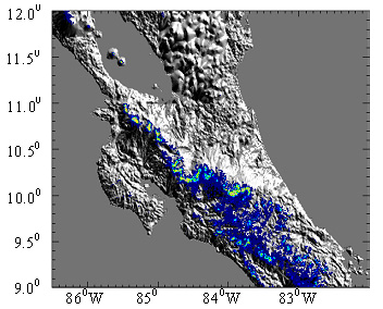
Satellite-derived cloud forest distribution over Costa Rica and Southern Nicaragua. Courtesy of Nair et al., 2008
SIGNIFICANCE TO THE PUBLIC TMCFs support high levels of biodiversity and are often at the core of biological hotspots – areas of high biodiversity where conservation is crucial to the preservation of global biodiversity.
TMCFs are islands of indigenous species and their small spatial scales and dependence on cloud water make them extremely susceptible to environmental and climatic changes at global and regional scales. In addition to their ecological
importance, TMCFs also are important water resources. Using NASA satellite data, it is possible to quantify cloud immersion and map cloud forest locations for conservation purposes, provide better understanding of ecological processes
and identify valuable water resources.
NEXT STEPS Satellite-derived cloud immersion can be used to understand the species distributions in TMCFs. Ongoing NASA-funded field work on the spatial distribution of tree and bird species at the Monteverde, Costa
Rica research site is seeking to relate species ranges to remotely sensed and modeled patterns of cloud distribution. This information not only enhances understanding of the factors constraining species, but also can be used to
predict ecological changes associated with climate change.
For more information, contact:
Lynn Chandler, Goddard Space Flight Center, 301-286-2806, lynn.chandler-1@nasa.gov
